Seattle.gov Home Page
Link to Department of Transportation Link to Seattle.gov Home Page Link to Seattle.gov About Us Page Link to Seattle.gov Contact Us Page
SDOT Blog Home Page SDOT Blog Home Page CityLink Seattle

ASK US A QUESTION!

Have a question about our current work at the Seattle Department of Transportation? We’re ready to get you an answer!

Click here and scroll down

Search SDOT Blog

Archives

Contact us

Call 206-684-ROAD

SDOT Photo Gallery


			SDOT Photos posted a photo:	The bascule portion of the Ballard Bridge is draped during painting. February 9, 2012

			SDOT Photos posted a photo:	This photo was taken while the bascule portion of the Ballard Bridge was being painted. The bascule is the center portion of the bridge that opens and closes for maring traffic. There are long approaches on each end of the bascule bridge. The bridge crosses Salmon Bay leading to the Lake Washington Ship Canal. February 9, 2012

			SDOT Photos posted a photo:	This photo was taken while the bascule portion of the Ballard Bridge was being painted. The bascule is the center portion of the bridge that opens and closes for maring traffic. There are long approaches on each end of the bascule bridge. The bridge crosses Salmon Bay leading to the Lake Washington Ship Canal. February 9, 2012

			SDOT Photos posted a photo:	The railings and other steel portions on the bridge were painted last year. This photo was taken on February 9, 2012.
More photos

Archive for July, 2009

SDOT Simple Solutions

UBridge_heat 011

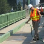
If you watched the local news last night, you probably heard the stories about the University Bridge closure due to the extreme temperatures.   Anticipating that the bridges would expand in the record-breaking heat, our SDOT bridge engineers had been carefully monitoring Seattle’s bridges all week.  All our other moveable bridges expanded, but not enough to compromise their ability to open.  The University Bridge, however, reached the point where the bridge leaves were touching.  We couldn’t open the bridge without damage.  Even if we had been able to open it, it wouldn’t have been possible to close it. The bridge provides a critical emergency response route across the ship canal so we closed the bridge to marine traffic on Wednesday night.

Thursday morning, our SDOT Bridge Maintenance crews came up with a low-tech, low-cost and creative solution to combat more expansion:  wet burlap sacks across significant portions of the bridge to keep it cool.  We watched the mercury climb with bated breath all day yesterday, but are happy to report that the sacks were a success and there were no impacts to maritime travel yesterday.  Many thanks to the Bridge Maintenance crews for their work and creativity this week.  Check out the pictures below and after the jump to see the burlap in action.

Read more »

[More]

Extra care for hot trees

Healthy Red Maple - leaves are healthy green - canopy is full - leaves are uniform size

Healthy Red Maple - leaves are healthy green - canopy is full - leaves are uniform size

Our record-breaking heat wave is subsiding.  But the need to protect Seattle’s trees from ongoing heat-related stress isn’t ending.  Even a normal Seattle summer can be hard on our urban trees, and the recent unusual temps have been especially tough.  Each tree we can help through the dry season contributes to the City’s goal of increasing our tree canopy coverage from 18% to 30% in the next 30 years.

SDOT’s Urban Forestry division just published a handy reference paper on how to identify a stressed tree and tips for how to care for trees in the heat.  Click here for more information and check out the photos below and after the link on the stages of tree stress.

Read more »

[More]

Input needed! Bike and truck improvements for south end Ballard Bridge

We’re trying to make it easier to move around the south end of the Ballard Bridge and want to hear from you.  SDOT held a small working session with bicycle, freight and pedestrian advocates and is recommending the following changes.
15AveW&EmersonJuly72009A-Model

If you bike or drive this corridor, we hope you’ll take some time to read the project web site and use your experience to give us input. Submit comments right here on our blog by Wednesday, August 12.

Update from SDOT:  Hi there. It’s exciting to see how many people are commenting and we thought you’d like to know how we are going to respond to input. By close of business Friday, August 14 we’ll add a blog entry that summarizes how comments are being incorporated and why. Be sure to check back!

Also, thanks for the heads-up about branches obscuring some of the signs at the south end of the bridge.  We’ll have Urban Forestry crews out there in the next week to evaluate and trim.  If you come across greenery blocking traffic signs in the future you can call (206)684-TREE and we’ll have someone take care of it.

Thanks.

[More]

Yesler Terrace’s Talented Eight

Who says urban design and transportation can’t be interesting…for teens? Certainly not the eight high school students who were participants in Seattle Housing Authority’s Yesler 2014 Summer Youth Program. Yesler 2014 aims to involve teens and young adults in the redevelopment of the Yesler Terrace neighborhood. With their help, the neighborhood’s open space, cultural spaces, pedestrian paths, and other features will be designed with a youth perspective in mind.

SDOT staff and Yesler 2014 students on discussing pedestrian access in their neighborhood

SDOT staff and Yesler 2014 students discussing pedestrian access in their neighborhood

Read more »

[More]

A smooth ride through SODO

The repaving of 4th Avenue South from Airport Way S to Royal Brougham Way was completed last week.  Check out the photos below for some lovely shots of velvety asphalt and gleaming paint lines. 

Looking north on 4th Ave S toward King Street Station

Looking north on 4th Ave S toward King Street Station

As we mentioned last week, the project used a new, energy-efficient form of asphalt mix, but that wasn’t the only thing noteworthy about it.  Crews were also able to complete the paving on the west side of the Royal Brougham intersection in just one night and wrapped up final striping, clean-up and restoration in time for the Torchlight Parade and weekend Mariners and Sounders games.

The 4th Ave S repaving is just one piece of work in Downtown that will improve streets and help keep traffic moving when major construction gets underway on the Alaskan Way Viaduct.  A smooth ride through SODO, brought to you by the Bridging the Gap transportation levy.

Looking south on 4th Ave S.

Looking south on 4th Ave S.

[More]

Bradford Trail Connector ready just in time for Seafair

A new trail link connecting Genessee Park to the surrounding neighborhood was completed on Friday just in time for Seafair.  The Bradford Trail Connector is ADA accessible and provides a new path to the park for all users.  Genessee Park is a popular place to watch the Seafair festivities, so the trail connection is likely to get quite a bit of use in its inaugural week.

A view looking toward the park at the location of the Bradford Trail connection before the improvement.

A view looking toward the park at the location of the Bradford Trail connection before the improvement.

Neighbors and visitors have been “voting with their feet” for years by carving out the informal foot path in the photo above. The idea for the connection formally emerged as the community put together its neighborhood plan.  It was funded through the Bridging the Gap levy.  Enjoy the show!

A view of the new trail connection, looking toward Genessee Park.

A view of the new trail connection with Genessee Park behind it.


The new trail, viewed from the bottom of the hill.

The Bradford Trail connection, viewed from the bottom of the hill.

[More]

Sidewalks + DIY art at Morgan Junction

If you spend much time around Morgan Junction, you may have noticed a newly installed sidewalk art project right next to Morgan Junction Park.  The project was created by the artists “SuttonBeresCuller” and is titled Salon.

Morgan Junction Sidewalk Art 1 

Salon represents something new for the SDOT Art Program.  It incorporates a series of stamped and stained concrete picture frames in the sidewalk at California Avenue SW & SW Eddy. The frames are a blank slate for neighbors and visitors to create changing works of chalk art. SDOT Street Maintenance concrete crews built the sidewalk and worked with the artists to stamp the concrete frames. The new park and restored sidewalk were dedicated on June 13th. 

The project involved collaboration between multiple City departments and a lot of support from the Morgan Junction community.  Walk on it, draw on it…and enjoy it.

Morgan Junction Sidewalk Art 2

[More]

Columbia City’s new link

 
A short but sweet new pedestrian facility connecting people & businesses in a great neighborhood.  Happy walking!
39th Ave S before the changes
39th Ave S before the new sidewalk
 
39th Ave S with the new sidewalk
This new sidewalk project completes a previously-missing gap in Columbia City’s sidewalk network.

It links the sidewalk along Rainier Ave S in the heart of Columbia City’s commercial district with the residential neighborhood up the hill to the east. These gaps exist in neighborhoods throughout the city.  Little by little, we’re working to fill them in.

[More]

Seattle #6 most walkable city…for now

Pine Street pedestrians

How walkable is your neighborhood? Everyone has an opinion on this, including the folks at Walkscore.com.  Walkscore recently ranked Seattle’s neighborhoods…and the city as a whole. We came in #6 nationally, behind the “big boys” such as San Francisco, New York, and Chicago.  (In the spirit of sibling rivalry, we will note that we came in above a certain city to the south at #10). 

Number 6 is pretty good, but Seattle has the goal of being the most walkable city in the nation, and we’ve got a new Pedestrian Master Plan to help us get there.

Walkscore uses destinations to generate the rankings.  It’s a good online tool that makes it easy to figure out what’s nearby, whether that’s a grocery store, a restaurant, or a park. But Walkscore doesn’t account for a lot of things that make or break a walk through the city like sidewalks, hills, trees, access to public transportation, or traffic volumes.

We think we’ve come up with something better—or at least more complete—as part of Seattle’s draft Pedestrian Master Plan. In addition to destinations, we’ve also looked at every intersection and every block in the city to see what needs to be done to make that part of Seattle more walkable. We’ve included all the things Walkscore doesn’t: sidewalks, crosswalks, signals, traffic, connections to transit, and much more.  Seattle’s stretching its legs and striding out towards #1.

Kids Crossing Street

[More]

You heard it here first – West Seattle Junction parking

Draft findings from the May West Seattle Junction parking study are hot off the press. Parking West Seattle Junction

The results?  Existing two-hour time limit signs in the commercial area along California Avenue SW seem to be working well.  SDOT doesn’t think paid parking is the right approach for the Junction at this time.

The parking study examined how full the parking spaces were and how many people were staying longer than the allowed two hours.  In the Junction’s commercial area, about 56 percent to 71 percent of parking spaces are generally full.  When 75 percent or more of the spots in an area are full it gets hard to find a parking space.  That’s our threshold for making significant changes to existing parking regulations, like the use of paid parking.  Compliance with the two-hour time limit signs was also high, meaning that the signs are working well to create customer turnover and paid parking isn’t needed at this time.

Check out the graph after the jump for the actual numbers.  Watch for a full report next month and a draft parking plan in the fall with any proposed on-street parking changes.   

Read more »

[More]