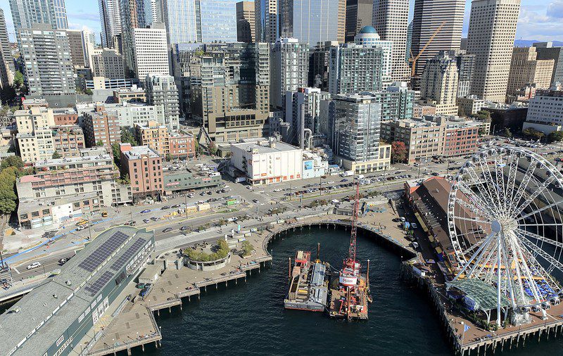
 Aerial view of Seattle's waterfront between Pike and Spring streets, 2019. Photo Credit: WSDOT
 Blog Stats: 1,200 words | 6-minute read
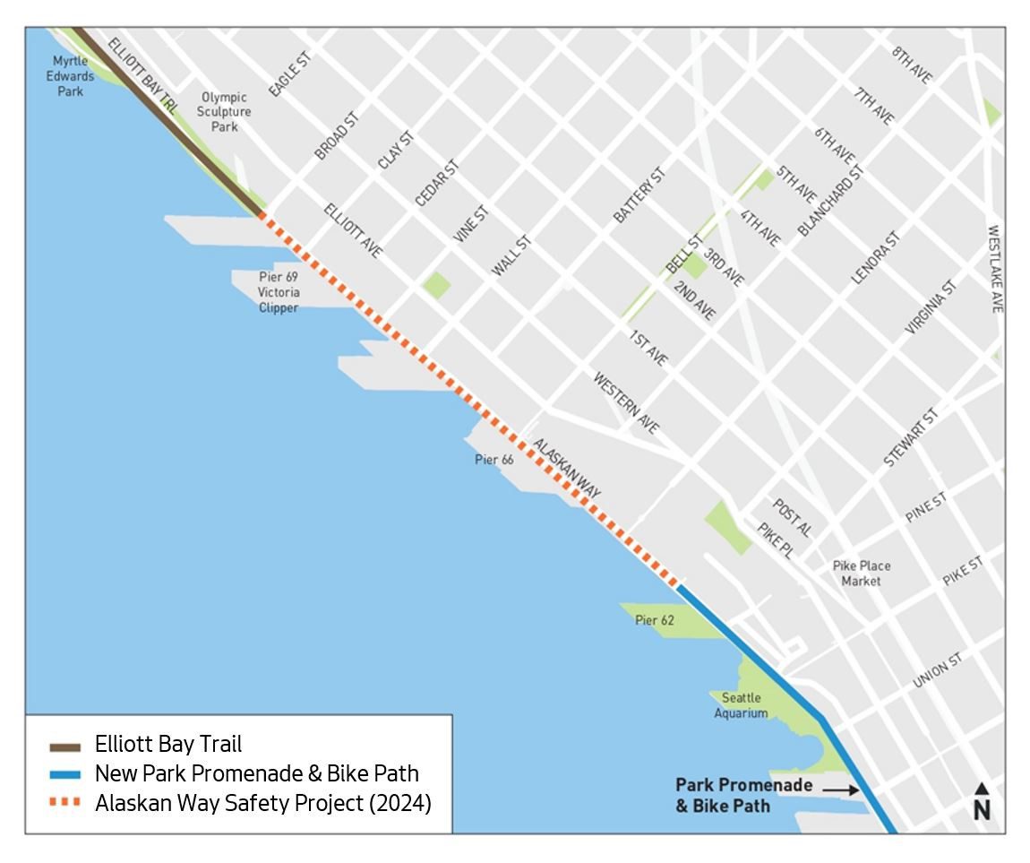
We’ve reached the 30% design milestone of a protected bike lane on Alaskan Way from Virginia St to Broad St! The connection creates an intuitive, safer route for people biking and scooting between the future Waterfront Bike Path and the Elliott Bay Trail.
At-a-glance:
- The Waterfront Seattle Program is constructing the Waterfront Bike Path, a two-way protected bike lane on the west side of Alaskan Way from S King St to Virginia St.
- The Alaskan Way Safety Project creates an intuitive, safer connection for people biking between the Waterfront Bike Path and the Elliott Bay Trail by building a new protected bike lane on the west side — also creating a buffer between people walking and driving.
- In response to community feedback, the design includes intersection improvements, lane reductions, and sidewalk and curb ramp repair.
- We expect to finalize the design this year and start construction in 2024. Now’s your chance to provide input.
We want to make it safer and more enjoyable for people to walk, bike, and roll between the new Seattle Waterfront Promenade and Bike Path at Virginia St and the Olympic Sculpture Park, where the Elliott Bay Trail begins. To contribute to a people-friendly space on Alaskan Way, we’re planning a new protected bike lane (PBL).
We’re working with The Waterfront Seattle Program, the Port of Seattle, and local bike advocates to reimagine a portion of Alaskan Way for people visiting and traveling along the central waterfront – while also keeping goods and cruise operations moving. Opening the Elliott Way Connection reduces traffic to the north on Alaskan Way, opening the opportunity to further make Alaskan Way a great destination. The project brings intersection improvements, lane changes, and sidewalk and curb ramp repair.
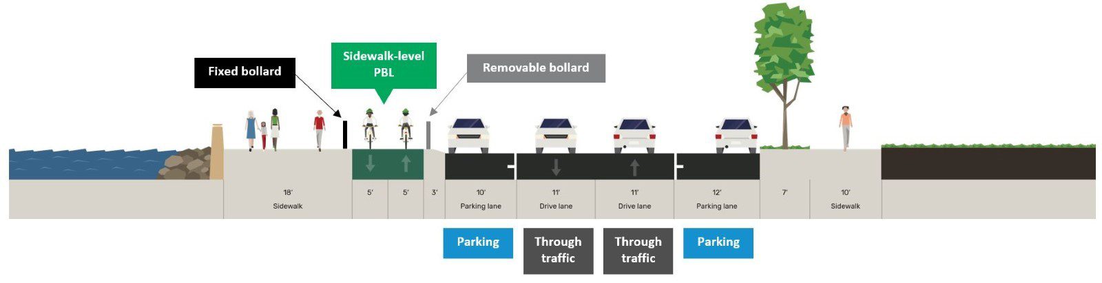
Features of our enhanced 30% design
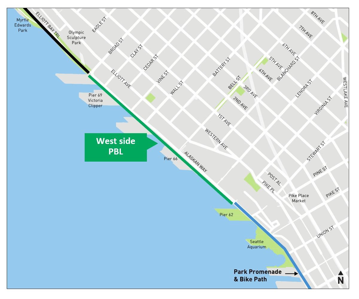
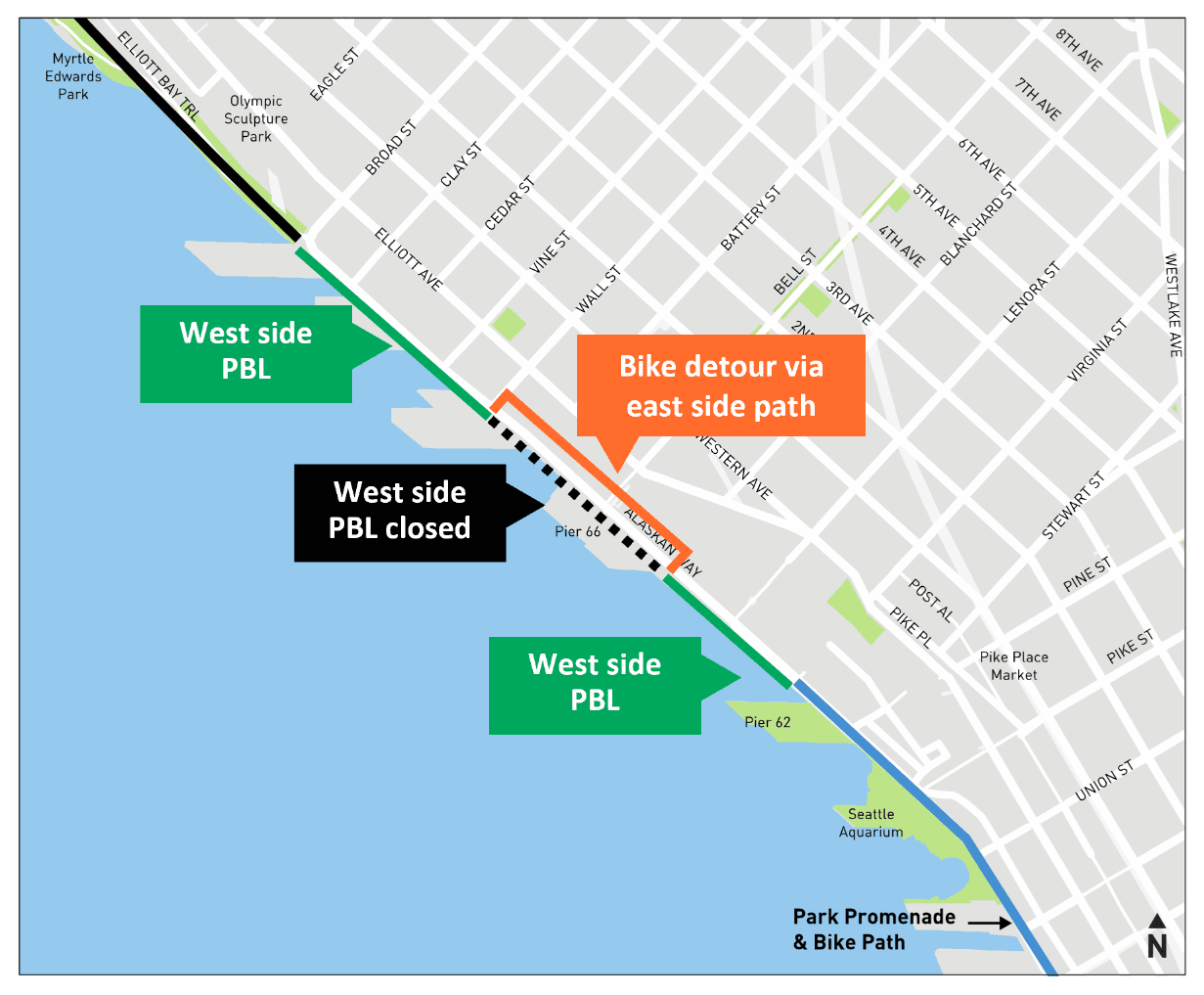
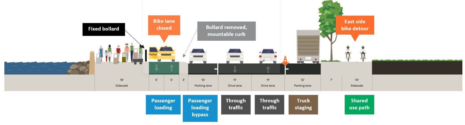
In response to community and stakeholder feedback, we’ve developed an updated design for a west side protected bike lane with an east side bike detour on cruise sailing days.
We worked closely with the Port of Seattle, bike advocates, and engaged with Pier 66 stakeholders and businesses to develop this updated 30% design concept, which responds to concerns around cruise ship sailing day traffic and pier access and maintains an intuitive bike connection.

We propose the following improvements:
- A continuous 0.6-mile PBL on the west side of Alaskan Way between Virginia St and Broad St. A continuous west side PBL provides a more intuitive connection for people biking by minimizing the crossings included in the original concept.
- An east side, two-way path from Blanchard St to Wall St will be installed for use on sailing days, when the west side bike lane in front of Pier 66 is closed.
- Lane reductions in this section of Alaskan Way, going from two northbound and two southbound vehicle lanes to one lane in each direction. This change is closely aligned with findings from SDOT’s Vision Zero Review, which showed that reducing lanes on multi-lane arterial roads slows people speeding and makes it safer for pedestrians. The street will continue to support freight movement and the changing traffic patterns resulting from Waterfront activities.
- Intersection safety improvements include adding Leading Pedestrian Intervals (LPI) to make people more visible to those driving, bike traffic signals, No Turn on Red signs, shorter pedestrian crossing distance, and vehicle left turn lanes at select intersections.
- Sidewalk repair and updating ADA-compliant curb ramps along the project corridor to improve access for people walking and rolling.
To read about our latest design concept in more detail, check out the project web page.
“Cascade Bicycle Club would like to thank the Seattle Department of Transportation, the Mayor’s office, and the Seattle Port Commissioners for listening to the community and designing an Alaskan Way bike trail that will benefit everyone who rides a bicycle along Seattle’s world-class, revitalized waterfront. Enabling people to ride on a continuous bike path on the west side of Alaskan way for the majority of the year, with a short detour when cruise ships are loading or unloading, is a safe and sensible solution that benefits people who bike and also meets the business needs of the Port.”
– Cascade Bicycle Club Executive Director Lee Lambert
“I’m pleased to see the robust design we’ve arrived at having worked rigorously within SDOT — including input from our Chief Safety Officer — and collaborated closely with the Port of Seattle and Cascade Bicycle Club in the last year. The new facility closes a crucial gap in the bike network to make it safer, and works with the complex needs at this cruise ship gateway.”
– SDOT Deputy Director of Capital Projects Francisca Stefan
We will be in the design stage of this project through fall 2023, and plan to start construction in 2024. We will continue to coordinate with the Port of Seattle and other stakeholders to ensure the west side protected bike lane and sailing day bike detour operate safely and comfortably for all users.
Project Background
When we started planning for this project in 2022, we heard from many Seattleites who use Alaskan Way regularly and are excited for the changes happening along our city’s central waterfront. Our new street design will help create a more accessible waterfront for both locals and visitors.
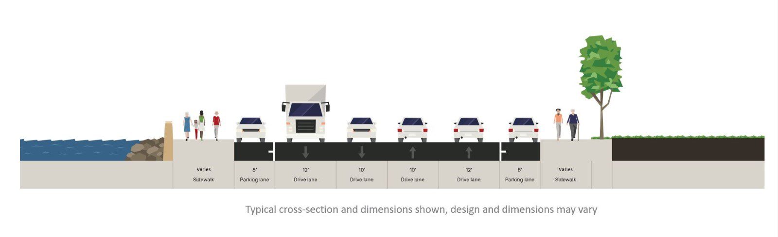
Our earlier 10% design concept from spring 2022 included:
- West side two-way protected bike lane at street level from Broad St to Wall St
- East side two-way shared use path along existing sidewalk from Wall St to Bell St
- East side two-way raised bike lane/bike path along former streetcar alignment from Bell St to Virginia St
The earlier design required people biking to cross Alaskan Way two times, even when a cruise ship was not in port. To reduce the chance of conflict between people biking and driving, our new concept allows people to stay on the west side of Alaskan Way most days of the year and only cross the street when a cruise ship is in port.
Want to know more or provide input?
Check out our web page for more detailed project information, and reach out to AlaskanWaySafety@seattle.gov if you have any questions or comments.