

Magnolia Bridge
The Magnolia Bridge was built in 1930 & has stood watching over Elliott Bay for nearly 90 years.
The Magnolia Bridge has seen a lot over the years. No, we’re not talking about the stunning view you enjoy while driving along the bridge (arguably one of the best viewpoints of downtown in Seattle); we’re talking about the bridge itself.
Ninety years is a long time and the bridge is showing its age. While the bridge is still safe to drive on, it’s not going to last forever. So in 2017, we launched a planning study to look into possible alternative scenarios for when the bridge needs to be replaced.

Image courtesy of Seattle Municipal Archives, Image 4582
We’ve been working on a planning study of 4 alternative transportation scenarios for when the bridge needs to be replaced.
-
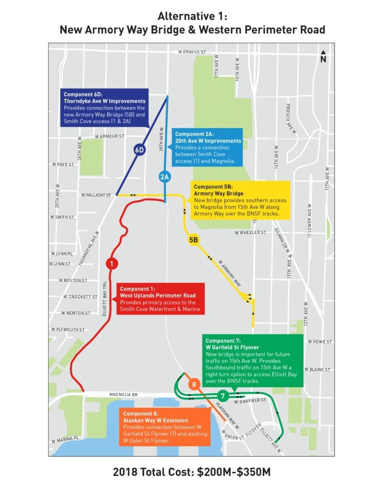
- Alternative 1: New Armory Way Bridge & Western Perimeter Road

-
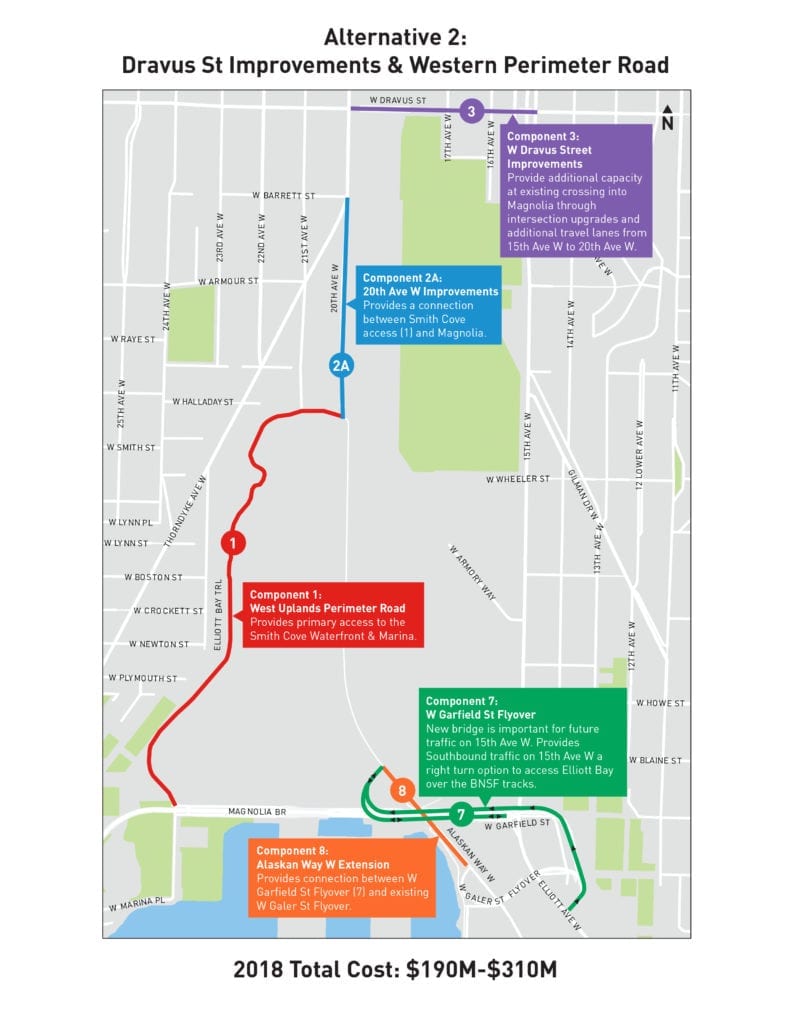
- Alternative 2: Dravus St Improvements & Western Perimeter Road

-
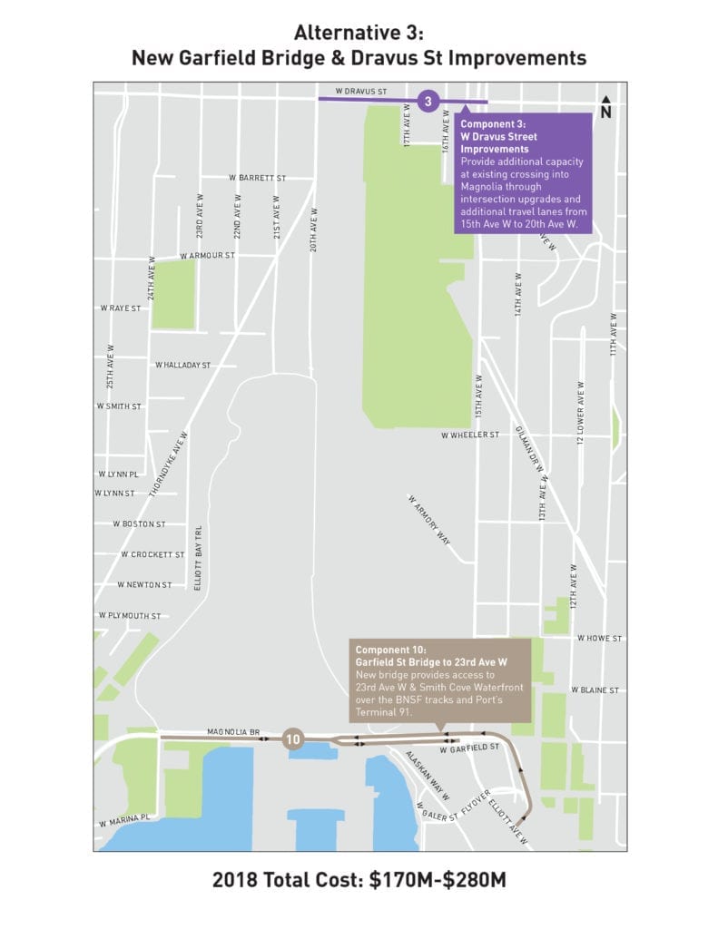
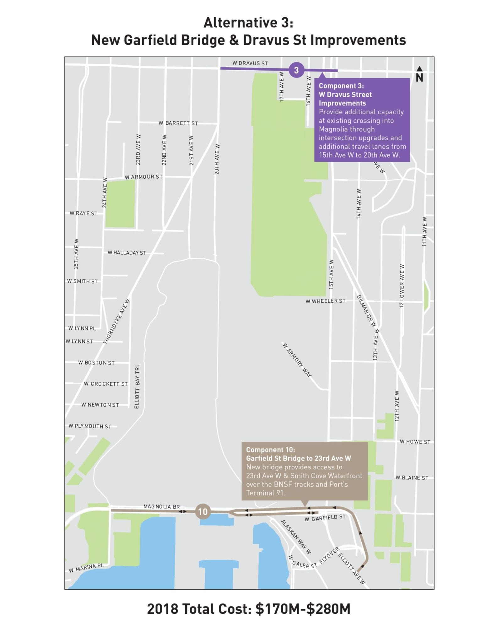
- Alternative 3: New Garfield Bridge & Dravus St Improvements
-
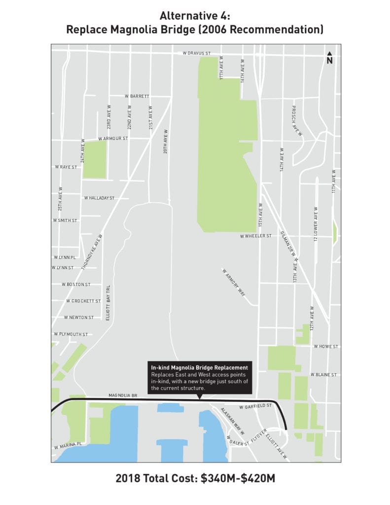
- Alternative 4: Replace Magnolia Bridge

We weighed alternatives based on factors such as:
- environmental impact,
- ease of mobility and access,
- cost,
- construction duration and impact, and
- how well each alternative would meet the needs of the community.
We also created an emergency transportation plan for unexpected closures. Read more about the results of this Magnolia Bridge Planning Study.
The Magnolia Bridge Planning Study was the first of ten studies funded by the Levy to Move Seattle to help us assess and manage roadway structure maintenance needs and maximize future investments. The studies are a part of our effort to better understand the size of Seattle’s maintenance backlog, which requires long-term attention.
With cost estimates spanning from $190M to $420M, bridge replacement and alternative options considered in this study far exceed available Seattle Department of Transportation funds without significant outside investment from our State or Federal partners.

Snapshot of community input.
We’ve briefed community organizations, worked with a stakeholder group, hosted drop-in sessions and launched an online survey to inform neighbors of the planning study, to understand their mobility and access needs and to gather input on alternative options to consider along with replacing the existing bridge. Throughout the process, we received a lot of valuable input.
We’ll continue to work with the community and elected officials to be creative in examining funding opportunities for the Magnolia Bridge and will also be launching a study of the Ballard-Interbay Regional Transportation System pending state-funding.

We’re also hosting a community engagement meeting to share the planning study results and answer questions on Thursday, June 6, at Catharine Blaine K-8 school in the cafeteria, from 6 to 7:30 PM.
Safety is a top priority. Our City & regional partners continue to examine potential mobility solutions for Magnolia.
And as we do so, we remain committed to maintaining the safety of Magnolia Bridge by conducting regular maintenance and frequent inspections in coordination with the Port of Seattle. We perform 24/hour monitoring to ensure the safe use of the Magnolia Bridge. Ongoing maintenance work includes repairing damaged concrete, as well as performing spot repairs.
Part of our planning study included an emergency bridge closure transportation plan in the event of a major earthquake or other events that make one or more of the bridges unusable. The intention is to consider the safety and resilience of mobility into and out of Magnolia in the event of a catastrophic earthquake. The short-term focus in the event of an unexpected closure would be on W Dravus St and W Emerson Pl, two bridges that have received extensive repairs in the past few years.
Read more about the study by visiting the Magnolia Bridge Planning Study webpage.
###