Seattle.gov Home Page
Link to Department of Transportation Link to Seattle.gov Home Page Link to Seattle.gov About Us Page Link to Seattle.gov Contact Us Page
SDOT Blog Home Page SDOT Blog Home Page CityLink Seattle

ASK US A QUESTION!

Have a question about our current work at the Seattle Department of Transportation? We’re ready to get you an answer!

Click here and scroll down

Search SDOT Blog

Archives

Contact us

Call 206-684-ROAD

SDOT Photo Gallery


			SDOT Photos posted a photo:	The bascule portion of the Ballard Bridge is draped during painting. February 9, 2012

			SDOT Photos posted a photo:	This photo was taken while the bascule portion of the Ballard Bridge was being painted. The bascule is the center portion of the bridge that opens and closes for maring traffic. There are long approaches on each end of the bascule bridge. The bridge crosses Salmon Bay leading to the Lake Washington Ship Canal. February 9, 2012

			SDOT Photos posted a photo:	This photo was taken while the bascule portion of the Ballard Bridge was being painted. The bascule is the center portion of the bridge that opens and closes for maring traffic. There are long approaches on each end of the bascule bridge. The bridge crosses Salmon Bay leading to the Lake Washington Ship Canal. February 9, 2012

			SDOT Photos posted a photo:	The railings and other steel portions on the bridge were painted last year. This photo was taken on February 9, 2012.
More photos

Archive for February, 2010

No Need For Words

An original and powerful approach to driver safety education created by the Sussex Safer Roads Partnership (UK). 

[More]

SDOT Work Down Under

Street view of areaway located on the south margin of S. Washington St, between 1st Ave S and the 1st/2nd alley.

Construction is coming soon on a project you won’t see a lot of…not because it’s in Australia (it’s not), but because it’s down under city streets.  The work is to stabilize an areaway. Areaways are the usable areas, generally in the street right-of-way, below the sidewalk and between building foundations and the street wall; that street wall holds back the earth below the road surface and provides support for the sidewalk. Most of the 115 areaways in downtown were created when City engineers raised Pioneer Square’s streets a full story following the Great Seattle Fire of 1889. Since many buildings were already under construction then, architects provided for two “ground floors” – the lower one at the level beneath the new sidewalks. Later that lowest, underground floor was sealed over.  In 2000, SDOT undertook a thorough study of the condition of the Pioneer Square areaways and, as a result, did some emergency repairs.  Work has continued, refurbishing and preserving several areaways, and now is about to start at S. Washington Street and First Avenue.

Underground view of areaway located on the south margin of S. Washington St, between 1st Ave S and the 1st/2nd alley.

The cobblestone retaining wall is in poor condition and has bulged out laterally. There is also a depression on the curb lane along the south side of Washington St. that may be a result of the lateral push. A temporary repair has been made to seal the cracks. But for the wall to continue to provide its function, a permanent restoration has to be made.

[More]

Look…A New Crosswalk!

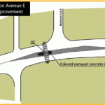
Pedestrian improvements are being made on E Olive Way in anticipation of the future construction of the Capitol Hill light rail project. In addition to a new marked crosswalk at E Olive Way and Boylston Ave E there will eventually be a median island in the center of the street. These efforts will help to provide a safer crossing for pedestrians. This crosswalk is a part of other efforts to improve pedestrian safety in the area and improve the reliability of buses that stop along E Olive Way. You can learn more about these efforts by clicking on the photo above to connect to a flyer with more information.

[More]

Have a minute? Take our Electric Trolley Survey!

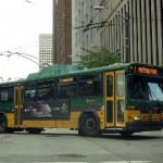
The City of Seattle is working with Metro to improve the electric bus routes. Metro electric buses (also called electric trolley buses) are powered by electricity from Seattle City Light, which produces zero net climate-altering emissions. In addition to being virtually carbon neutral, electric buses are approximately twice as energy efficient as diesel, diesel hybrid, or natural gas fueled buses.

The County’s electric buses are due for replacement in 2013-14.  King County is considering the replacement of electric buses with diesel hybrid vehicles and will begin a detailed analysis of trolley alternatives in 2010.  Decisions will be needed in 2011 for purchasing a new fleet in 2013-14.

We’d love to hear from you!  Take our survey here and read information on electric buses here.

[More]

Helping You Plan Ahead

Want to stay on top of traffic advisories in the area? Check out SDOT’s On the Move blog here. You’ll find up-to-date information to help you plan your commutes or trips. You can also subscribe to our Twitter feed here for additional alerts on collisions, closures, and incidents. Get connected today!

[More]

No Phone Zone

Distractions are the leading cause of motor vehicle collisions in America and the number one distraction is cell phones.  There’s no doubt that distracted driving is a major issue on our roadways.  According to the National Safety Council, twenty-eight percent of traffic accidents occur when people talk on cellphones or send text messages while driving.  

This issue has been getting a lot of press lately.  Lawmakers throughout the country are looking to tighten regulations on cell phone use while behind the wheel.  U.S. Transportation Secretary Ray LaHood has made reducing distracted driving a top priority of his administration, groups like FocusDriven have organized to increase public awareness of the dangers of cell phone use while driving, and even Oprah Winfrey has started focusing this traffic safety issue. 

Do your part to keep our roads safe.  Check out Oprah’s excellent website highlighting the dangers of distraction, take a quiz to find out what you know about the issue, and sign the pledge to make your vehicle a no phone zone. 

Distract driving billboard from the Rainier Traffic Safety Project. Look for similar billboards on Aurora Avenue North this summer.


[More]

Mercer Gets the TIGER

So the big news is out – Mercer got the TIGER.  The what? …the Transportation Investment Generating Economic Recovery discretionary grant.    The Obama Administration rolled out $1.5 billion in TIGER grants this week and the Mercer Corridor Project got $30 million.  Granted (no pun intended), we didn’t get the full $50 million requested, but smart work by SDOT teams along with a very competitive bidding environment is saving money. Projects such as the Spokane Viaduct Widening Project are coming in under budget and helping to potentially bridge some of that gap.

Governor Chris Gregoire, Senator Patty Murray and Mayor Mike McGinn joined together today at the site of the Old McKay building, on the corner of Westlake and Mercer, to announce the award and to announce that demolition of eight vacant properties will begin in the next few weeks. 

Old McKay Building Demolished in September 2009


Construction on the Mercer project is expected to start this summer.  The project will create 1,200 direct construction jobs and provide opportunities for minority contractors and apprentices. More than 245,000 people work in Seattle’s greater downtown today, and 50,000 additional jobs are expected by 2024. To learn more about the future two-way Mercer click here.

[More]

Final Parking Plan Released for Capitol Hill

SDOT has just released its final parking plan for Capitol Hill.  We had a tremendous response to the draft parking plan.  The final plan takes into account the comments we have received.

SDOT’s Community Parking Program has been working in Capitol Hill for a full year.  In January 2009, SDOT began assessing Capitol Hill on-street parking, working with neighborhood businesses, residents, and community groups.  There were walking tours in February, and a parking occupancy study was completed in March. SDOT staff presented study findings and potential solutions at a Parking Open House in September. A draft parking plan was released in October 2009, and over 200 comments were received from residents and businesses. The final parking plan that SDOT developed has been strongly informed by this community process. 

Implementation of the parking changes will take place in 2010, starting with changes along E Olive Way in March 2010.

For more information, and to view the final plan, please click here.

[More]

Reduced Staffing at SDOT on Furlough Days

To address the economic downturn, city employees will be taking unpaid furlough days to help with the city’s budget.  The Seattle Department of Transportation (SDOT) will participate by splitting the furloughing of its staff between two days in each furlough period.

Please expect to see reduced staffing at SDOT on the following days:

January 15 and 19     July 2 and 6   
February 12 and 16 August 6 and 9
March 12 and 15 September 3 and 7
April 9 and 12 October 8 and 11
May 28 and June 1 December 23 and 27

Please be patient with our staff as there will be fewer employees to assist you on these days.  While we may need to adjust our business practices due to the reduced staffing, SDOT remains committed to providing first rate service to our customers.

If you have any questions about the city’s furlough policy or SDOT’s service adjustments, please contact the department by calling 684-ROAD.

Thank you for your understanding.

[More]

Green with Envy Over Greenwood?

Nearby roads may be envious now that Greenwood Avenue N is looking so spiffy.  The improvements between N 105th and N 112th streets wrapped up this week, with some newly added elements.  A new crosswalk was installed on the Holman Road side of the intersection at Greenwood Ave N and N 105th Street following a multitude of public requests – and of course traffic reviews to support its inclusion. 

New sidewalk at Holman Road side of intersection at Greenwood Ave N/N 105th Street

Also, traffic analysis of vehicle counts and patterns showed the majority of southbound vehicles on Greenwood Avenue North turn west onto Holman Road, so to ensure vehicles can make this turn during one traffic signal cycle, SDOT designed for two right-turn-only lanes.

105th/Greenwood Ave. Intersection looking North

Looking South at N 107th - After Construction

The Greenwood Avenue North Street Improvement Project was slated for completion near the end of 2009, but the work had to be extended into 2010.  That’s because during construction crews encountered some unforeseen underground obstacles. The project scope was expanded to work around the obstacles, and to upgrade the storm drainage system as well as use concrete in the outside lanes instead of asphalt.

[More]