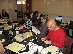
 Members of SDOT's Incident Management team gathered in the "operating center" as they participated in a citywide earthquake emergency exercise.
 You’ve no doubt heard the slogan “three days three ways” advising all citizens to prepare to survive for three days after a disaster. Here in the northwest that disaster may well be the “big one” – the major earthquake that geologists have been predicting; in fact, they say we are well overdue. While everyone is responsible for preparing themselves and their families for a catastrophic emergency, governmental agencies are also training and organizing to jump into action.
Earlier this month, SDOT participated in this mock emergency exercise along with representatives of regional agencies including King County, Washington State and the Federal Emergency Management Administration (FEMA) Region 10 office. The exercise took place over two days allowing for two full sets of staffs to participate and was designed to test response and related procedures starting 24 hours after the earthquake.

Members of SDOT’s Incident Management team gathered in the “operating center” as they participated in a citywide earthquake emergency exercise.
With the hypothetical situation that major roads were blocked, and most area bridges were either significantly damaged or totally collapsed, SDOT’s emergency teams focused on identifying what routes were open and which were not and then developing detours. First and foremost, SDOT needed to first secure safe routes for emergency responders and emergency services such as access to hospitals. Furthermore, SDOT had to determine how to clear roads, what equipment and supplies would be needed and where and how to obtain them.
An exercise such as this provides SDOT’s planners and engineers to pre-plan detours according to different sets of circumstances. One particularly helpful outcome of the exercise was SDOT’s creation of a map that can be pulled up immediately to track and reflect roadway closures and damaged roadway structures. The map simplifies the process of quickly identifying needs and detours. Were there to be a real emergency, this map would be combined with other City mapping layers such as shelter and community points of distribution (CPOD) locations and then made available to the public via the internet and media outlets.
As a result of identifying CPOD locations during the earthquake exercise, on June 14 our City logistics team conducted a full-scale movement of CPOD resources into a designated location, set up the site to be operational and demonstrated the capability of distributing basic necessities such as food, water, diapers etc.
In August, there will be two tabletop exercises to discuss longer term recovery issues that we would still be facing a year after a disaster.