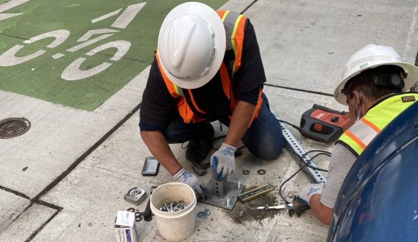
 Magnetic and light sensors will detect when a vehicle occupies a curbside space. Our crews installed this equipment in Seattle’s Belltown neighborhood in April 2021. Photo credit: SDOT
 The situation
While it may not be the first thing that comes to mind when thinking about transportation infrastructure, curb space serves a vital role in our system for activities like package deliveries, passenger pick-ups and drop-offs, and other loading and unloading needs.
As our city and region continue to grow, alongside increased demand for deliveries during the ongoing COVID-19 pandemic, the efficient use of curb space becomes all the more important. There are currently more than 5,000 different curbside loading zones within the city of Seattle, which community members and businesses rely on to deliver and receive a wide range of packages, products, food, and other supplies.
The challenge
Despite the seemingly large number of curbside load zones in Seattle, it can often be difficult for delivery drivers to find one of these load zones because the spaces may already be occupied, or are too small, or they may not be able to find a zone near their destination.
When delivery trucks and other vehicles need to spend time looking for a usable space, it can mean double-parking and sometimes blocking bike, bus, or general travel lanes, as well as increased congestion, delayed deliveries, reduced air quality, and higher costs to customers and community members.
Addressing the challenge – with enhanced data!
To meet this ongoing challenge, we have collaborated with other cities and private companies across the country, who all share a common goal of improving access and productivity of our limited curb space. This effort is currently being led and coordinated by the Open Mobility Foundation (OMF), an open-source non-profit organization that creates a governance structure around open-source mobility tools. This collaboration identified a need to create a standardized way to digitally define our loading zones and measure their effectiveness.
The result of this collaboration over the past 14+ months is the creation of a new open-source Curb Data Specification (CDS), which was co-created by more than 160 people from public transportation agencies, curb space users, and technology companies. We anticipate the CDS will be a helpful part of our overall response to addressing delivery challenges around the city. Beyond Seattle, other cities and local governments across the U.S. are planning to deploy this specification in curb pilot programs, and even around the globe. A beta (test) version of the CDS is slated to be released soon.
So what is a “CDS” and how does it work? Great questions!
At its core, a Curb Data Specification (CDS) is a set of protocols that allow data to more effectively be shared between cities, curb users, and curb data providers, allowing for better awareness of and insights into how curb spaces are currently being used, and how they could potentially be better used in the future.
The CDS provides a consistent data standard by leveraging open-source capabilities to help address curb space challenges. The CDS will enable cities to digitally represent curb zones and proactively optimize commercial loading activities for both people and goods in the future. We can then directly measure the effectiveness of curb zones both individually and on a larger scale.
When implemented, the CDS will create a publicly available digital representation of the loading zones currently marked by physical signs on our streets today. This digital feed will tell a curb user where, when, and for how much time they can park to load. The CDS also standardizes how we record and measure the activities happening along our curbs and could tell us in almost real-time how well a particular loading zone is performing. Are there double-parked trucks because of too many deliveries? Is the zone empty most of the day? These are the insights we hope to gain by programming the CDS into how we address curbside management.
The specification is made up of three primary “Application Programming Interfaces,” or APIs, listed below:
- 1) Curbs: A way for cities to specify a curb loading area and pertinent regulations and share more precise information with companies and the public.
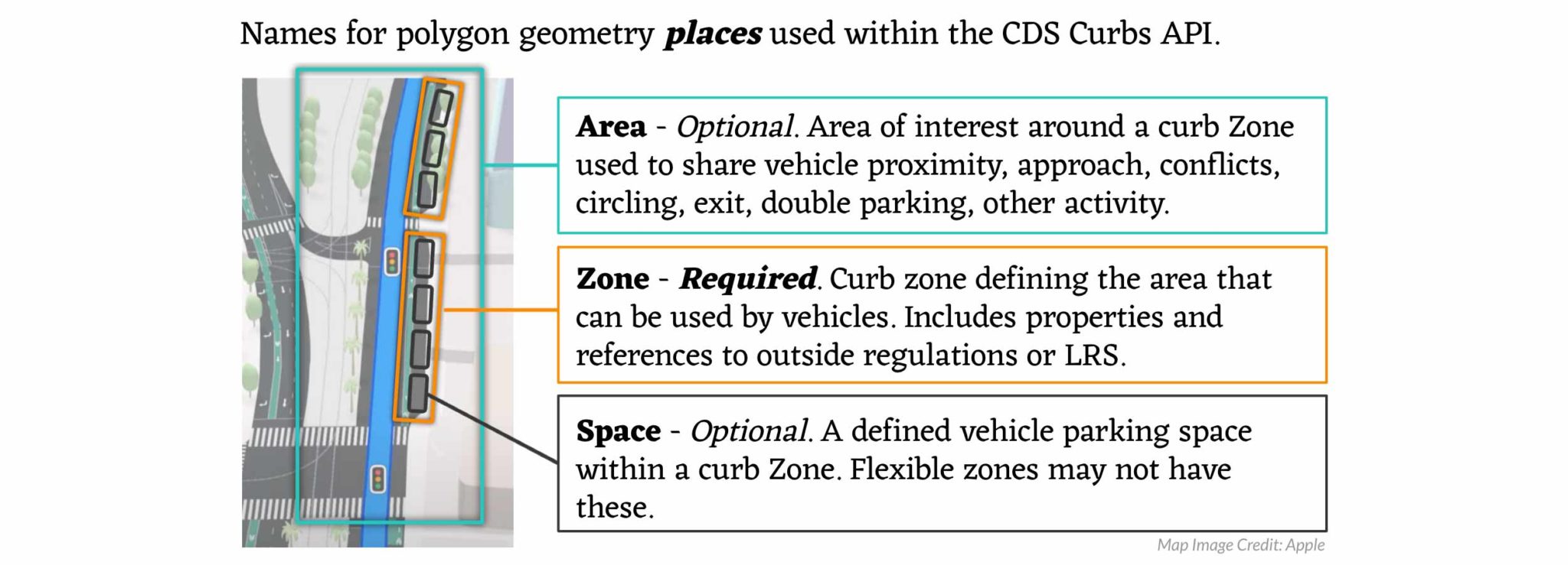
- 2) Events: Real-time and historic usage data from real curb locations can be sent to cities, third parties, and/or researchers. This information can originate from commercial company data feeds, sensors, payments, check-ins, enforcement, or other City data sources. No personal information is captured or shared through the Events API.
- 3) Metrics: Calculations to determine how efficiently a curb space is being used. This includes how long vehicles are parked (dwell time), how full the spaces are throughout the day (occupancy), how many vehicles use the space (usage), and other aggregated statistics in curb areas.
What are the potential benefits?
Implementing the CDS program and bringing it up to scale can provide a number of potential benefits, which our team looks forward to evaluating. This includes:
- Reduced congestion
- By matching delivery vehicles with the best fitting curb space, software will provide the best route, helping to limit circling and decrease double parking.
- Better parking (with real-time data, when sensors are present)
- Check out our Blog post from April 2021 regarding a study we conducted in Seattle’s Belltown neighborhood, including what we learned to help make parking more accessible and support future uses. The CDS will be able to directly connect to real-time sensors.
- Improved communication and engagement
- This system will make it easier for curb space users to find and use available loading zones, while serving as a robust, beneficial tool in community conversations while planning potential changes in the future.
- More efficient curb space management based on more precise data
- We expect that the improved data that will become available will help support more effective curb space use, allowing us to:
- Support our electrification and climate goals.
- Improve curbspace regulations to increase access for people who need it most.
- Identify underutilized loading zones that may have more beneficial public uses such as public space, mobility parking, paid parking, transit lanes, or bike lanes.
- We expect that the improved data that will become available will help support more effective curb space use, allowing us to:
- Greater flexibility for the future and lower costs using open-source system
- The open-source, collaborative nature of this effort helps prevent being limited or locked into a single vendor, giving us and other municipal transportation departments increased flexibility to adapt to a rapidly evolving and emerging field of work.
- The flexibility and predictability of open-source and nationally adopted standards will result in lower costs to local governments, and thereby to the public.
Next steps
We will continue to help to shape and improve the Curbside Data Specification this year, and our team is working towards implementing a publicly accessible interface to better understand and harness this new dataset as it begins to be implemented.
We look forward to sharing more updates and information in the coming months as they become available. Thank you!