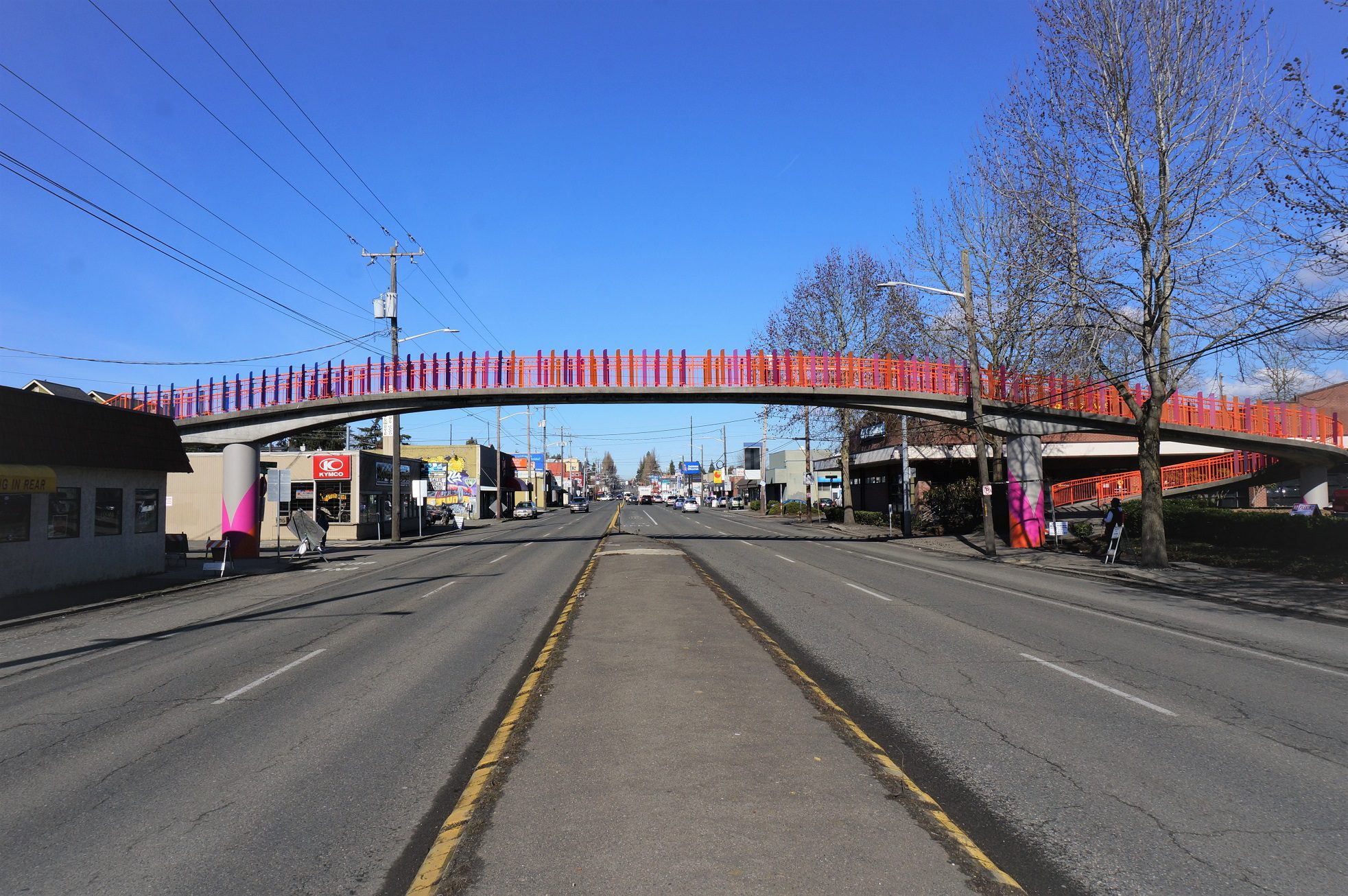
 Community art on a pedestrian bridge on Aurora Ave N, looking north at N 102nd St. Photo: SDOT.
 Editor’s Note (9/30/2022): This blog post was updated to note that the survey has been extended through October 7, 2022.
Summary:
- We’re planning improvements to Aurora Ave N as part of the Aurora Ave Project and want to hear from you via our quick survey, open now through October 7, 2022!
- Please share your experiences traveling on Aurora and what you’d like to see improved in the future.
- This blog post includes details about the project, outlines its purpose and objectives, and highlights some of the safety challenges that exist today along Aurora Ave N.
- We have other projects coming up in and around Aurora, including the Green Lake Outer Loop Project, which is scheduled to begin construction as soon as September. We’re also considering options to extend the bus-only lanes on Aurora Ave N, including the potential addition of a new northbound Business Access and Transit (BAT) lane between downtown Seattle and the Aurora Bridge.
- Lastly, we’re participating in a series of community neighborhood walks in August as part of the Aurora Licton Urban Village Home Zone in development. The walks are scheduled for August 3, 10, and 17 at 5:30 p.m., and August 20 at 10:00 a.m. See our flyer for additional details, including meeting locations.
Aurora Ave N connects communities, people, and goods throughout north Seattle and beyond. However, like other major arterial streets in Seattle, Aurora Ave N has continued to see a concerning and tragic trend of life altering and life ending crashes. Today, the street remains an uncomfortable place to walk, roll, or bike. Safe travel can be especially challenging for people with disabilities or other mobility needs. That’s why the Aurora Ave Project is studying ways to make it work better for all users.
In addition, access to transit must be improved. This study will also identify ways to improve transit safety, speed, and reliability, and create better transit connections. We’re partnering with King County Metro in this work, and look forward to closely coordinating with Metro on future improvements in the corridor. We’re also working with the Washington State Department of Transportation (WSDOT), who is a major project funding partner and helps manage Aurora Ave N, also known as State Route 99.
Engaging communities in the planning process
We’re seeking community perspectives to inform the project through an initial round of public outreach. Please take our quick survey and share your experiences traveling on Aurora Ave N. Your responses will help us better understand community priorities and interests, and design improvements to help address your concerns.
The survey will remain open through October 7, 2022. It is also available additional languages on our website, including Chinese, Korean, Spanish, Tagalog, Tigrinya, and Vietnamese.
Survey links below:
Project purpose and objectives
The Aurora Ave Project will:
- Create a design for the Aurora Ave N corridor that enhances safety, mobility, and accessibility for all travelers.
- Identify potential transit service improvements and connections (e.g., with nearby light rail stations), as well as safety and security improvements (e.g., at transit stops).
- Address the needs of residents, businesses, and corridor stakeholders in a unified vision for the corridor through an equitable and robust engagement process.
- Consider collision history and safety challenges along the corridor, addressing the areas with the most serious collisions or collisions involving vulnerable road users.
- Develop a strategy to construct corridor improvements as resources become available.
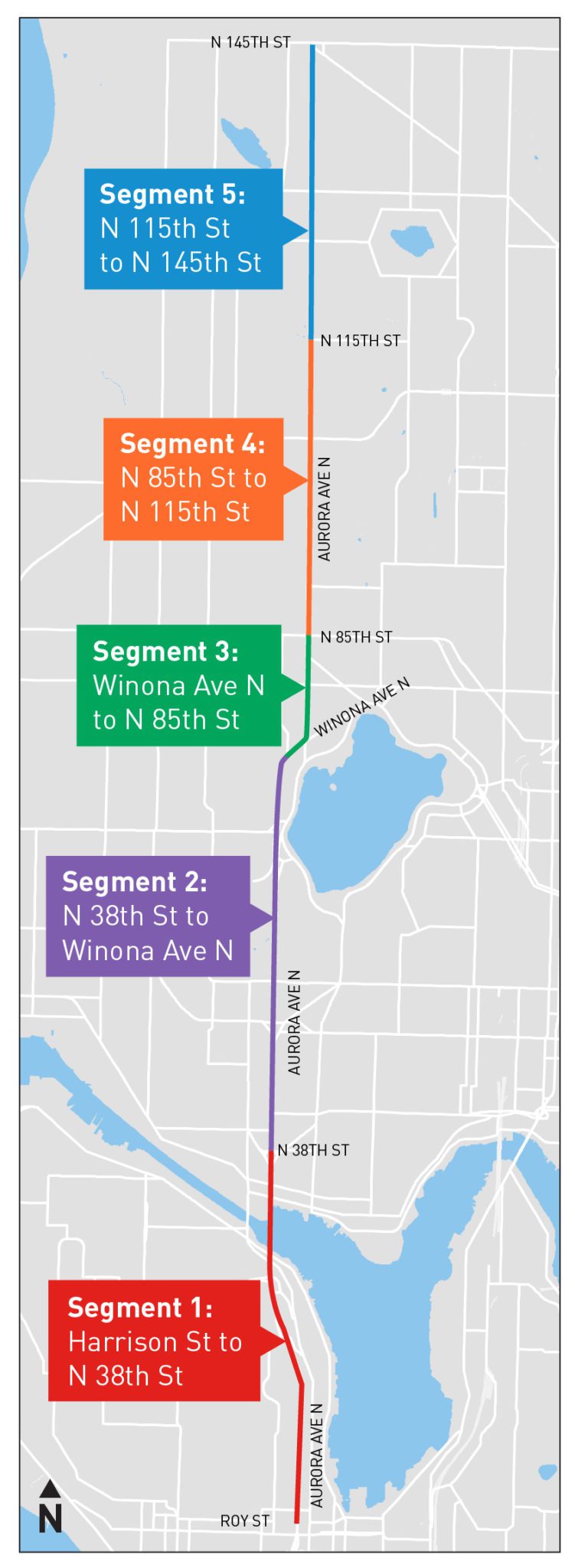
A long corridor running through North Seattle
In order to best serve local neighborhoods, residents, and travelers along the nearly 8-mile corridor we’re studying, we’ve broken Aurora Ave N into 5 segments. They extend from Harrison St at the north end of the SR 99 tunnel, all the way to N 145th St, at the northern city limits of Seattle. Each segment is home to vibrant communities with distinct land use and urban village contexts, street cross sections, and access needs.
- Segment 1: Harrison St to N 38th St
- Segment 2: N 38th St to Winona Ave N
- Segment 3: Winona Ave N to N 85th St
- Segment 4: N 85th St to N 115th St
- Segment 5: N 115th St to N 145th St
- Additional area: N 145th St to Mountlake Terrace (King County Metro RapidRide E Line assessment only)
What’s ahead
- Summer/Fall 2022: Survey #1 to understand key concerns (we are here)
- Winter 2023: Design workshops to develop design alternatives
- Summer 2023: Survey #2 to receive feedback on the design alternatives
- Fall 2023: Share preferred alternative
Quotes:
“Aurora Ave N connects vibrant communities throughout north Seattle and is an important travel route for people to get to work, childcare, grocery stores, and other essential destinations. I look forward to seeing the results of SDOT’s outreach and the ideas developed with community to improve safety and mobility along Aurora Ave to better serve the traveling public moving forward.”
– Seattle City Council President Debora Juarez
“We are excited to have launched public engagement on the Aurora Ave Project and to work together with community members and businesses along Aurora to hear ideas for improving safety, mobility, and livability. We know safety is a major concern and we are dedicated to partnering with the community as we develop plans for improvements to the Aurora Ave corridor. We’re also working closely with our partners at King County Metro and the Washington State Department of Transportation to ensure a robust, holistic approach to the planning process.”
– Jim Curtin, Seattle Department of Transportation
“Metro is looking forward to understanding what changes to Aurora Ave. N. can make transit faster and safer for our riders and improve their experience on this vital corridor.”
– Christine O’Claire, Mobility Division Director for King County Metro
“The SR 99/Aurora Avenue North Planning Study ranked high in WSDOT’s Pedestrian/Bicyclist Program based on the significant safety need. With its crash history on a wide, fast, busy road, this represents what we designate as a gap in the state active transportation plan based on the high level of traffic stress and lack of separated facilities for people walking and rolling. The project also ranked well for the high value it will provide for the many people, businesses, and modes including transit access, for its contribution to transportation equity, and for project quality. SDOT clearly demonstrated they’ll carefully and thoroughly investigate the technical aspects of the corridor for active travel and work to truly understand the needs and concerns of the people using Aurora Avenue. With the funding the Legislature provided under Move Ahead Washington for the future construction phase, this street will be transformed.”
– Barb Chamberlain, Director, Active Transportation Division, WSDOT
“In one day, on Friday July 15, ten people walking and biking were hit on Seattle’s streets. It’s urgent to reimagine how people and goods get around on Seattle’s streets, especially on Aurora Avenue. The Aurora Reimagined Coalition is excited to see the Seattle Department of Transportation, King County Metro, and WA Department of Transportation collaborating on this corridor-wide safety study. This holistic effort can lead to a long-term reimagining of Aurora and Seattle’s other most dangerous streets.”
– Lee Bruch, Aurora Reimagined Coalition (ARC)
Funding sources
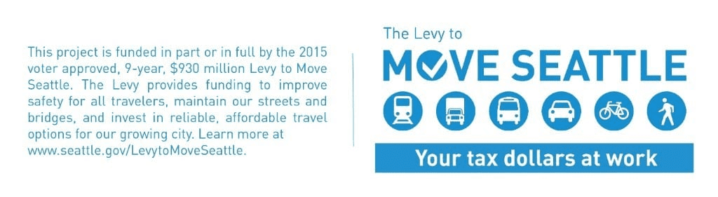
This project is made possible by the voter-approved Levy to Move Seattle and the Washington State Department of Transportation (WSDOT) Pedestrian and Bicycle Program. King County Metro is also contributing funding to the project and partnering in our community engagement efforts. The Washington State Legislature also allocated state funding via the 2022 Move Ahead Washington funding package, which we detailed in an April 2022 blog post.
How to stay informed
- We encourage you to sign up for project email updates to stay informed about the latest public engagement opportunities for the project.
- You can also reach us if you have any questions at aurorastudy@seattle.gov or (206) 905-3620.
Translated information
- If you need this information translated, please call (206) 905-3620.
- 如果您需要此信息翻譯成中文 請致電 (206) 905-3620.
- Kung kailangan mo ang impormasyon na ito na nakasalin sa Tagalog mangyari lamang na tumawag sa (206) 905-3620.
- Si necesita traducir esta información al español, llame al (206) 905-3620.
- Nếu quý vị cần thông tin này chuyển ngữ sang tiếng Việt xin gọi (206) 905-3620.
- 이 정보를 번역해야 하는 경우 전화하십시오. (206) 905-3620.
- እዚ ሓበሬታ እዚ ኺትርጐም እንተ ደሊኻ በጃኻ ደዊልካ (206) 905-3620.
Thank you for your interest and engagement in helping make Aurora Ave N safer for everyone.
Other projects in the area
Green Lake Outer Loop Project
We’re building the Green Lake Outer Loop project, which will provide a better-connected loop path around the outside of Green Lake Park. This means safer, more comfortable travel options for people walking, running, biking, and rolling, as well as connections to surrounding neighborhoods in the area. Construction will start as soon as September.
Potential bus-only lanes on a section of Aurora Ave N
We’re also coordinating with WSDOT on options to extend the bus-only lanes on Aurora Ave N, including the potential addition of a new northbound Business Access and Transit (BAT) lane between downtown Seattle and the Aurora Bridge. We’ll share more information about this potential expansion of the bus-only lanes soon.
Aurora Licton Urban Village Home Zone neighborhood walks in August
Community members will host SDOT team members on a series of community walks this month. Please attend a walk and share your concerns and thoughts about neighborhood improvements. The walks are scheduled for August 3, 10, and 17 at 5:30 p.m., and August 20 at 10:00 a.m. See our flyer for additional details, including meeting locations. If you have questions, you can contact Neighborhood.Traffic@seattle.gov or call (206) 684-0353. Thank you.