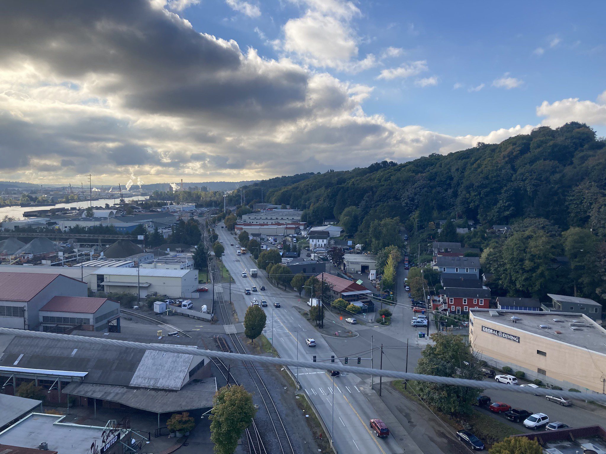
 View of West Marginal Way SW, looking south from the West Seattle Bridge. Photo: SDOT.
 Blog stats: 1,200 words | 7-minute read
Editor’s Note (March 27, 2023): Project construction is scheduled to begin in early-April. For more information, please visit the project web page or read this construction notice.
At-a-glance:
- Reduced West Marginal Way SW to one southbound lane in fall 2022 to test traffic conditions and collect data
- Findings:
- Driver travel times increased by 2 seconds per trip along the corridor
- Driver speeds dropped from 43 to 37 mph (12% decrease – posted speed limit is 30 mph)
- It varies seasonally, but on average there are between 100 to 200 people walking and biking per day
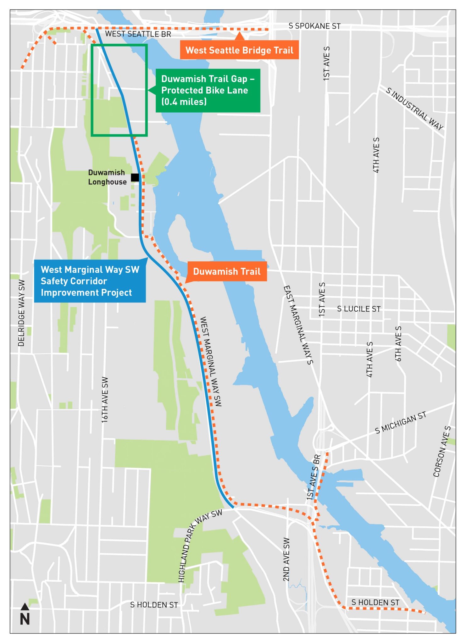
- The West Marginal Way SW Safety Corridor Improvements Project enhances:
- Safety and visibility at 17 driveways crossing the Duwamish Trail on the east side of the street
- Biking by closing a nearly half-mile gap in the biking and walking network
- The Spokane St Swing Bridge Rehabilitation Program continues in 2023 and will include planned closures
- Community conversations continue about enhancing safety along West Marginal Way SW
Through collaboration with the community, we identified safety improvements on West Marginal Way SW as a priority for all travelers, especially people biking and walking, as a way to cross the Duwamish River during the West Seattle High-Rise Bridge closure. As we engaged local businesses and people who drive large trucks, we heard a strong interest in making driveway access movements safer and speeds slower.
The West Marginal Way SW Safety Corridor Improvement Project increases awareness of driveways crossing the Duwamish Trail. It also adds a nearly half-mile long on-street protected bike lane (PBL) between Marginal Pl SW and the existing Duwamish Trail signalized crossing near SW Idaho St, closing a crucial gap in the regional walking and biking network. When complete, West Marginal Way SW will be a more predictable space for all travelers.
In July 2021, we announced the construction of a new bike lane when the West Seattle Bridge reopened. Our approach to designing this project is data-driven and incorporates the input of people who use West Marginal Way SW. We first collected data and completed an analysis of potential impacts in 2020. After the West Seattle Bridge reopened last September, we updated the data.
In 2021 and 2022, we talked and met extensively with stakeholders, nearby businesses, and interested community groups, including walking tours and virtual open houses. The engagement aligned with an outreach and project identification program conducted during the bridge closure, Reconnect West Seattle. Conversations continue in 2023.
We expected the reopening of the West Seattle Bridge and the removal of temporary detour routes to change travel patterns. So, we worked with adjacent businesses to identify a time for testing the project’s potential impacts by temporarily closing one southbound lane (where the new PBL will be located) for 2 weeks. This trial allowed us to test how the single southbound lane of West Marginal Way SW operated.
The trial took place from October 23 through November 6, 2022, and collected the following data:
- Driver volumes
- Walking and biking counts
The cumulation of additional data we collected and analyzed confirmed the following:
- Verified negligible impacts to overall operations of West Marginal Way SW. The two-week trial closure and our traffic models indicate modifications will increase travel time by 2 seconds per trip.
- Indicated a speed reduction after the project is completed. Speeds decreased by 12% during the lane closure (from 43 to 37 mph on average). The posted speed limit is 30 mph, and with the permanent installation of this project, we anticipate speeds to move closer to the speed limit.
We also collected turning movement data and performed a safety assessment of all the existing Duwamish Trail driveway and street intersections in late-August 2022. Drivers of large trucks turning into and out of these driveways are concerned about blind spots, especially when turning right. To help address concerns, we are designing pavement markings on all approaches to the driveways to remind people biking to slow down and be aware of trucks. Signs will also be installed at the driveways along the Duwamish Trail to remind drivers to approach cautiously and watch for trail users.
A deeper dive into the 2-week lane closure
Driver speeds
During the two-week lane closure, driver speeds dropped. The median speed was 37 mph, which remains above the 30 mph speed limit. We observed long queues at the Duwamish Trail crossing signal.
Closing one lane can reduce vehicle speeds and help eliminate high-speed passing. Speeds decreased by 12% in the lane closure area, and by 2% in other locations in the project area. Our experience shows a 10% decrease in speed can reduce all crashes by 20%.
Driver volumes
Driver volumes dropped by approximately 60% after the West Seattle Bridge reopened. During the closure, West Marginal Way SW was a primary detour route and saw a significant increase in vehicle traffic.
Today, traffic patterns are back to lower levels of approximately 15,000 vehicles per day. During the two-week lane closure, we saw daily traffic volumes as low as 12,500 vehicles per day.
Walking and biking counts
The number of people walking and biking on the Duwamish River Trail varies seasonally but ranges from approximately 100 to 200 people per day. During a typical day, this translates to 20 people walking or biking per hour. Better connecting this area by closing the gap in our network could double the number of people biking and walking.
Safety assessment of driveways and intersections
A thorough assessment of the 17 driveways and intersections along the existing Duwamish Trail completed along the corridor included counts at each driveway and crash history. Multiple site visits documented existing site conditions and observations of interactions.
Safety along this corridor is our top priority. We are implementing best practices along the driveway and intersections to increase visibility and awareness of conflict points and encourage people driving and biking to interact with each other at slower speeds. Helping people driving and biking with good sightlines at these crossings are critical. We have already trimmed overgrown vegetation to increase visibility along the Duwamish Trail.
We are also planning to:
- Include median islands
- Install new signs
- Paint pavement markings with bright colors and the word “SLOW” to alert people of an upcoming driveway
- Use existing rumble strips to slow the speeds of people biking
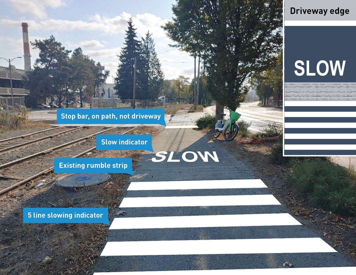
These changes will provide a more consistent look and feel, with some variation of interventions due to site context, at all 17 driveway crossings on the Duwamish Trail.
Next steps
- A temporary bike lane along West Marginal Way SW is currently in place, as it was being used as a detour route when the low bridge was recently closed for emergency repairs. In the coming months, there will be additional planned closures of the low bridge and detour routes as we continue to rehabilitate it.
- Community conversations continue on enhancing safety along West Marginal Way SW and we will continue to provide updates.
Stay informed
- Web: Visit our website
- Email us: WestMarginalWay@seattle.gov
- Call us: (206) 400-7511